
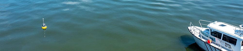


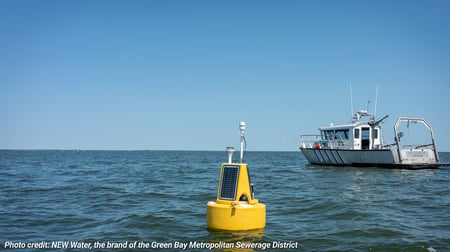
For 40 years, NEW Water has helped build a better understanding of water quality in the Bay of Green Bay through ongoing aquatic monitoring. Today, new and upgraded wave buoys are expanding that work, with funding from a Great Lakes Observing System (GLOS) grant, providing valuable data on waves and weather to support public safety, scientific research, and a water quality data.
Environmental Monitor Magazine story is found below. To see the story, please visit: NEW Water's New Wave Buoys: Safety, Science, and 40 Years of Monitoring Green Bay | www.fondriest.com
NEW Water’s New Wave Buoys: Safety, Science, and 40 Years of Monitoring Green Bay
By Stephanie Andrews | October 2026 | www.fondriest.com
In northeast Wisconsin, the waters of the Fox River meet Green Bay–often cited as the largest freshwater estuary in the world–before continuing their unhurried journey through the Great Lakes. As mixing waters converge, they each contribute their unique signature of chemicals, sediments and dissolved minerals, each telling the story of the landscape they flow through and its past and present. At one point, the Fox River was considered to be the most heavily industrialized river in North America. While the impact of manufacturing is now less acute, it is nonetheless still measurable in the water. Today, its watershed is predominantly agricultural, and the Fox River is the source of approximately one-third of Lake Michigan’s total phosphorus load. Established in 1931, NEW Water, the brand of the Green Bay Metropolitan Sewerage District, provides wastewater treatment and conveyance services in Northeast Wisconsin. It now serves almost 240,000 residents in a 285-square-mile area and treats an average of 41 million gallons a day across two facilities.
NEW Water’s Green Bay Facility was completed in 1975 and was the first wastewater treatment facility in the US to treat both municipal and pulp mill wastewater. Located on the mouth of the Fox River, it discharges treated wastewater into the river.
“We know that our most important resource is water,” says Dr. Sarah Bartlett, Water Resources Specialist at NEW Water. “For many reasons, we started a monitoring program 40 years ago, so that way we can take care of the water that we are working with on a daily basis.”
Forty Years of Monitoring
Monitoring began at NEW Water’s outflows at the mouth of the Fox River in 1986, extending into lower Green Bay with 20 sites making up the Aquatic Monitoring Program. The program also deployed a monitoring station at the Green Bay Entrance Light (GBEL) in 1986 and another station at the mouth of the Fox River in 1994–and both were still in place when Bartlett joined the organization almost a decade ago.
While not unique in its objective, Bartlett explains that what sets this monitoring program apart is its continuous dataset–“We have one of the longest-running water quality monitoring programs in all of the Great Lakes.”
She continues, “It’s really unique to have this program in longevity that is a committed resource, and it allows us to be a really strong partner with others in the area.”
Through continued efforts, partnerships and funding–including from the Great Lakes Observing System (GLOS)–NEW Water has upgraded and expanded its monitoring equipment to enable real-time monitoring.
In 2026, a grant from GLOS enabled an upgrade to GBEL from an older NexSens buoy platform and the purchase of two entirely new buoy systems.
New Buoys in Lower Green Bay
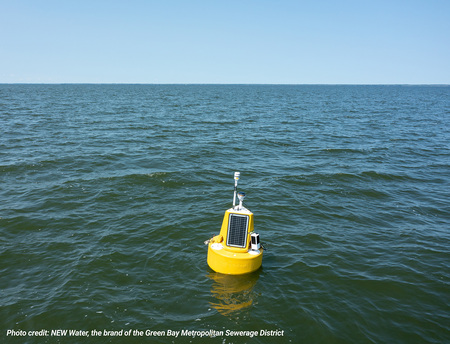
For the NEW Water team, selecting reliable, plug-and-play systems that offered cost-efficiency was front of mind. They settled on XB-200 buoys–a “huge upgrade” on the legacy systems–outfitted with X3 data loggers, Airmar 200WX weather stations and a SeaView Systems SVS-603HR wave sensor.
The additional buoyancy on the XB-200 also offers room to grow if system requirements change in the future.
The GBEL buoy is also equipped with two YSI EXO2 sondes, measuring five characteristics including dissolved oxygen, temperature and conductivity one meter from the surface and one meter from the bottom.
Wave Measurements in Green Bay
Bartlett championed efforts to secure wave monitoring buoys. While the safety of her team was a priority, the possibility of sharing this data, filling a knowledge gap and providing a community resource were also clear benefits.
 “We’re out on the water once a week,” Bartlett remarks. “The Great Lakes are considered inland seas, and conditions can change rapidly. Even if conditions don’t change rapidly, what you might be comfortable with on maybe a smaller water body is vastly different than going out and recreating and navigating out on Green Bay. It can be dangerous.”
“Green Bay is a world-class recreational fishery, so we know that we are getting people onto our body of water that might not have a lot of experience recreating.”
Possibilities of a Growing Dataset
There are now four buoys equipped with wave sensors located every five miles from the mouth of the Fox River out into Green Bay.
Deployment locations were chosen to complement existing buoy systems, provide data around popular boat launches, and capture data on conditions beyond Long Tail Point, which acts as a natural breakwater for Bartlett and her team as they head out into the Bay.
Data from the buoys is telemetered via cell from the data loggers every 30 minutes, where the team can access it internally via WQData LIVE in near-real time–something Bartlett says has been a “huge benefit” to the team.
Data from all the NEW Water monitoring stations is available to everyone–from educational institutions to the public–on the Seagull network and is updated every hour.
The data contributes to the four decades of research led by NEW Water in the Lower Green Bay area–“We sit on just this plethora of data, and there’s just not enough time to tease out all the details of it,” Bartlett reflects.
In the short-term, she hopes that the wave dataset will be used by people actively recreating, but in the long-term, she hopes that others may bring their expertise and use the growing body of data for research or modeling.
Indeed, with such a rich historical record of water quality data in this area, Bartlett picks out an interesting trend–“We’re seeing truly that we had a slight increase in what the surface water temperature is for Lower Green Bay.”
Partnerships to Understand Green Bay’s Modern Problems
Green Bay’s waters continue to respond to natural and anthropogenic changes. Not only does this dataset represent an important reflection point, but also an opportunity to consider what the future might hold.
“One water quality issue we have been measuring with our GBEL buoy is this persistent pocket of hypoxia,” Bartlett states. “We know where it sets up because we know the general flow of water within the bay–there’s a lot of buoys currently out there.”
Working with partners at the University of Wisconsin-Green Bay to share buoy resources and data, teams are getting closer to understanding the geographical and temporal extent of hypoxic dead zones, how this is changing in response to longer, warmer summers, and its corresponding impact on fisheries and recreation.
Bartlett is hopeful about the future of the new wave buoys. Although the project is initially earmarked to last two years, she hopes their value will mean their lifespan in this role is extended.
For now, there is still a lot to learn about Green Bay. While understanding water quality has been and continues to be a priority, the new addition of wave measurements promises new insights into a waterway in constant flux.
Learn more about this project here >>
Check out water quality data directly on the GLOS Seagull Platform here >>